As we made our way up the dirt road we could tell by the muddy roads that there would be at least some snow on the ground. We found a pull out just big enough for our group at a picnic ground that made a great spot to air down, which also meant our first chance to chat about the plan.
There was some debate on whether we’d be able to make it to the top of the trail, which ends at about 12,000 feet. Although it was late in the season, the sun was shining and I felt pretty confident we’d make it most of the way, if not all the way to the top. “It would all depend on how big the drifts were on the shelf road” was my response when asked again on the ham radio.
The turnoff for Geneva Creek should have been a no-brainer, but since I lent both of my GPS Data Cards from FunTreks out for testing, I chose the wrong fork and took half the group down the wrong fork and took half the group down the wrong trail. Luckily I realized the error quickly and we were able to get turned around. Once on the proper trail, we immediately had fun bashing through the 4”-6” of snow on the ground.
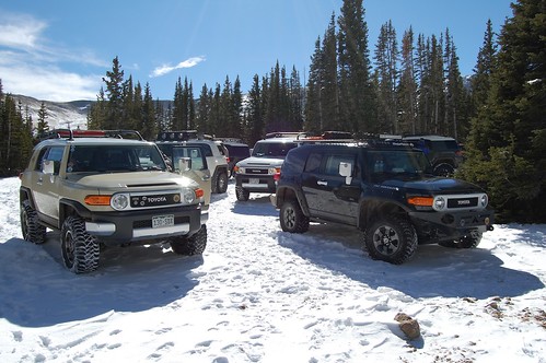
As we moved up the trail and gained elevation the snow began to get a little deeper, but still less than the 10” or 12” limit for mountain driving in our modified FJ Cruisers. About halfway up the trail (as shown in the FunTreks book) it begins to climb via a narrow road through the trees. At this point we were just past 10,000 feet in elevation, and since the slope faces south the snow was still very manageable even in the areas shaded by trees. We were able to get some really cool video of trailblazing this area of snow and we pushed up the trail.
Just past the last fork in the road, we continued uphill to the right and our entire group made it to the final area of trees near the top of the trail. We stopped here for lunch and a few brave souls hiked up a some of the very steep hills for a better view. There was barely a cloud in the sky and at around 11,500 feet we were just about at tree line. We could see the trail continuing in two different directions from here.
The fork to the west was clearly covered in deep snow as it climbed past the trees to about 11,800 feet. To the right, we saw the faint outline of a trail covered in snow, and since this wasn’t a steep trail for about ¼ mile we decided to give it a go. I asked everyone that was interested in pushing a little higher to follow me, and every FJ did. That lasted about 200 yards before I hit a major drift, at least 18” deep and about 10 feet long. After several unsuccessful attempts at pushing through it, I backed out and let a couple of other FJ’s try. Eventually, after about 10 tries, Antonio in his VooDoo Blue FJC with 35” tires managed to break through this last drift and we were well on the way again.
Our day ended just shy of 12,000 feet at the beginning of the final switchbacks on the Geneva Creek Trail. All eight trucks made it to the final spot, but we decided that attempting the switchbacks in the cold and snow wouldn’t be the best idea. We were able to position all the FJCs for a great photo op, and remarked on how few people ever get to see Colorado from this viewpoint, especially in the snow.
The ride down was fairly uneventful as we all took our time crawling back through the slippery snow. While climbing up is fun, descending takes great care to ensure you don’t slide and go sideways. Everything ended out great though, and a few of us remained at the junction with 285 to get aired up. Overall it was another amazing day on the trail with the Colorado FJs.
More Photos!
[flickr set=72157628827625201]
To get your copy of the January 2012 issue of FJC Magazine:

 A gorgeous Saturday morning greeted our fairly large group of FJ Cruisers in Bailey, Colorado. The goal for the day: the top of Geneva Creek. While this particular trail wouldn’t challenge a stock FJ Cruiser under normal circumstances, the end of October means cold temperatures and the chance of significant snow drifts in the Colorado high country.


