We were directed aboard and so on were fighting the swift current, the ferry angling up stream to make an arc to hit the landing on the other side. We debarked and after a couple of blocks were in the world-famous Dawson City. I couldn’t believe I was in Dawson City Yukon, some place I thought I’d never visit, but here we were!
Over 100 years ago, Dawson City was the epic enter of the 1896 Yukon gold rush. When gold was discovered, word spread around the world there were riches to be made with gold nuggets lining the rivers and dotting the countryside. Many traveled the treacherous overland route from Skagway, AK over the Chilkoot or White Pass carrying the one ton ofspecified supplies mandated by the Canadian government. The Canadian Mounties had the job of collecting the import duty on these mandated supplies.
Once over the mountain, the “Stampeders” had to cross Lake Bennett and get onto the Yukon River to Dawson City, a journey that took about a year. The other route, known as the richman’s route, also took a year, was by steamer leaving Seattle and traveling along the west coast of Alaska, and then on a river boat on the Yukon River to Dawson City. It didn’t matter what route these fortune seekers took; the gold rush was over the day they heard the news and made their plans. From the time gold was struck and the year it took to get to Dawson City all the gold claims had been staked.
Yet Dawson City has remained and there are people still working gold claims, looking for the motherlode. But there is something else besides gold that has beckoned many a person to Dawson City Yukon as well.
The Sour Toe Cocktail challenge was conceived of in 1973 after a jar with a preserved human toe was found in a cabin. Legend has it in the 1920’s, a rum runner developed frostbite on his foot and lost his toe. As a remembrance, he saved his necrotic toe in a jar with alcohol. Placing this toe in a shot of liquor became the Sour Toe Cocktail. Since 1973, over 100,000 people have taken the challenge. This past August two more people earned their sour toe certificates.

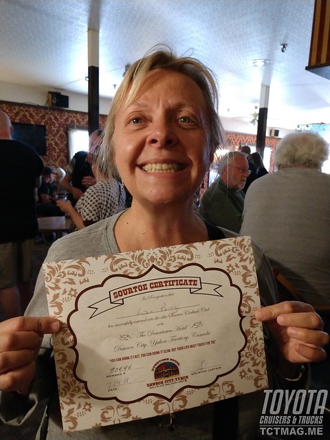
The Sourdough Saloon had a crowd of about 100 people and at least 10 people in line for a chance to kiss the toe. Lisa and I got our shots. As we stood in line, we could see the black, shriveled appendage on a bed of white salt. We heard the “toe master” chant “Drink it fast, Drink it slow, but your lips, have gotta touch the toe!”
Being the Gentleman Adventurer, Mrs. Badlands expeditions went first. She sat down in front of the toe with a look of why am I doing this? I reminded her for better or worse. The toe master picked up the toe and presented it to Lisa to kiss. A quick peck and she quickly drank her shot of Yukon Jack. As soon as it happened it was over, and Lisa was a proud member of the Sour Toe club. I quickly took my place, kissed the toe, downed my shot and I too was a member. We both received certificates to commemorate the occasion.
Back on the ferry we went and then on to our campsite in the Provincial campground. Every Provincial campground we stayed at was very nice with free firewood and clean campsites.
The next day, we toured Dawson City. It was gloomy as we crossed the Yukon river and parked along the main street. Playing with the radio we found an FM station (106.9) playing an eclectic mix of music and commentary. It reminded us of the TV show Northern Exposure.
We strolled around town and were impressed at some large residences off the main drag. The Jack London museum and Robert Service cabin were special places for me. I grew up reading Jack London with To Build a Fire -- a favorite story, and my favorite poem is by Robert Service:
"The Men That Don't Fit in"
There's a race of men that don't fit in,
A race that can't stay still;
So they break the hearts of kith and kin,
And they roam the world at will.
Once again, I marveled at being someplace I had dreamt about and now I'm there. I know I would never have made this trip without Lisa's prodding to do an unplanned trip. Quite the statement of adventure and support from someone who had never gone camping and was used to the luxury of civilized living.
We visited the modern and informative Danoja Zho Cultural Centre, which gave us a look into the life of the First Nations peoples of the area. We met back up with Larry and decided to explore the hardware store. The inventory of gold pans, portable sluices and other gold prospecting equipment are evidence of Yukon's long mining heritage. The old lifestyle of the Yukon is still alive for people who want it.
The plan was to drive to Carmacks, get on the Robert Campbell Highway and start heading home. Since we were passing the turnoff for the Dempster Highway, we would stop and take pictures. We had talked about driving to Tuktoyaktuk after the Deadhorse trip but decided it would add another several days to getting home. We had almost two weeks of steady driving and over 3500 miles to get home.
We left Dawson City and passed by the tailing piles and artificial lakes left behind by the massive gold dredges operating during the gold rush days. The turn off for the Dempster Highway was a short distance from Dawson City and soon we were stopped at the sign and taking photos.
Tombstone Territorial Park was only 50km up the road and boasted a beautiful visitors center. Although the road was dirt it was hard packed and smooth, so we quickly arrived at Tombstone. The Interpretive Center was a beautiful wood constructed building with nice bathrooms. The exhibits were very informative and soon we were looking at the map. Before we knew it, we were on the road north to Eagle Plains, which is halfway to Inuvik NWT and boasts a hotel, bar, restaurant, filling station, repair shop and campground.
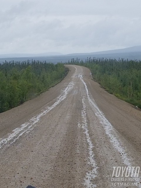
The The scenery was spectacular, driving through the forest and crossing numerous creeks. We saw mountain goats clinging to side of a rocky cliff and surprised some Dall sheep crossing the road.
We stopped at a sign commemorating the RCMP dog sled patrols from Dawson City to Ft McPherson. These Mounties would spend two to three months patrolling, taking mail, checking on residents and exploring the region. In 1911, a patrol never returned, and a search party found the members dead. This was The Lost Patrol, an important chapter in the history of the RCMP.
We were soon on top of Ogilvie Ridge. The views were fantastic, and we marveled at our fortune to be able to experience such vistas.
There were some signs on the latrine and information board about an aggressive grizzly bear in the area with a special warning to bikers. Taking a break at the lookout was a group of about 10 bicyclists accompanied by a support van and trailer. They were on their way to Inuvik. The entire trip we were surprised at the number of bicyclists on this remote highway.
As we were descending the ridge it started to rain, and the road became muddy. I put the FJ60 into 4 high and the BFG KM2 M/T's earned their keep.
Breaking the monotony of breathless views, the manmade structures of Eagle Plains came into view. The rain stopped and the sun came out, an omen that we made the right decision. We checked in and pulled into the gravel camping area. There were only a couple of other campers at the site but as everywhere we went, we attracted attention with the two Land Cruisers. Soon we were answering questions about our travels and trading notes with our campmates.
As we prepared for dinner, we were beset upon by an unkindness of ravens. The raven is the provincial bird of the Yukon and is known to be intelligent. These birds were ready to distract and pounce on anything left out. We practiced our rock throwing skills while we cooked up some Coq au Vin in the pressure cooker. We ate with a beady eyed audience cawing at us in envy.
With dinner finished and dishes done, it was time to check out the bar. The bar was rustically decorated with all sorts of animal mounts. What wildlife we didn't see in real life we could see up close on the wall.
Also, on the walls were pictures with the history of the 'Mad Trapper of Rat River'. The 'Mad Trapper' was wanted by the RCMP and led a posse of Mounties on a 150-mile one-month long chase with firefights where a Mountie was killed, and a couple more wounded. The 'Mad Trapper' was finally killed, though his identity was never learned.
The bartender was from the Czech Republic and we had an interesting conversation about her travels around the world and how she ended up here. The sun shone brightly through the windows of the bar, but we knew it was time to hit the rack. Tomorrow we were heading back south and head home. It was late July and we had been gone since May 25th.
Related Articles
The next morning, it was pouring rain and heavy fog. Visibility was less than 100 yards, so we decided to go inside for breakfast and wait it out. I made a request on my InReach for the weather. The fog should be lifting in a couple of hours.
After a couple of hours, the fog lifted, and the rain subsided. We were only about hour from the Arctic Circle so we thought we are this close why not go and we could have bragging rights of reaching the Arctic Circle twice. The rain had stopped but the road was of a soupy consistency.

The miles went by and soon we were at the Arctic Circle sign. Without speaking we got back in our trucks and headed North. Next was the Border with the Northwest Territories. Another photo op at the sign and we realized we were going to Inuvik.
The Peel River rivals the Yukon in size, and we stopped on the riverbank to wait for the Abraham Francis ferry. It was just our two vehicles waiting. As a matter of fact, we had not seen anyone since we left Eagle Plains.

The Abraham Francis ferry is a cable ferry. A heavy cable is strung from the riverbanks with enough slack to sink below the water surface so boat traffic can pass over it. The ferry vessel has a winch amidships that grasps the heavy cable and winches the vessel across the river. Soon we were on the opposite riverbank and waved at a couple of adventurers heading south.
We had arrived at Fort McPhearson, the home of the Fort McPhearson Tent & Canvas Company and the graves/memorial of the Lost Patrol. We picked up some organizer bags and headed back on the Dempster north bound to Inuvik.
A short drive later we were on the bank of the Mackenzie River. The MV Louis Cardinal was our next ferry. Unlike the previous ferry, this ferry used screw propulsion. The ferry left the bank headed upstream against the strong current. We made a long arc and landed right on the ramp. Great driving by the Captain.
Inuvik was a short drive away. It was weird to have been driving through so much wilderness to see billboards as we entered town. We went to Happy Valley Territorial Park where there were showers and laundry available but no vacancy. Off to plan B, another territorial campground just outside of town. The campground was okay, on the top of a hill and very windy. We were tired so we simply boiled up some water and had some Mountain House for dinner. Perfect for an evening like this.
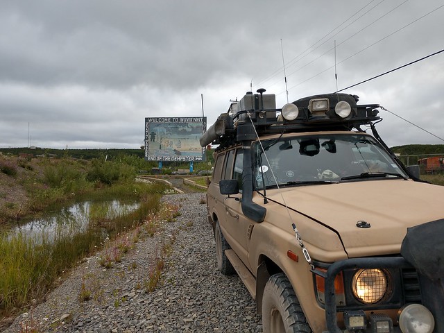
Waking up in Inuvik we were excited at the prospect of driving to Tuktoyaktuk on the newly opened Inuvik-Tuktoyaktuk Highway. We headed out and drove through town passing the visitors center and Igloo church.
As we headed on our way, we chatted on the radio how lucky we were to be making this trip. The highway was opened in November 2017, less than a year earlier, and we were traveling on it before it became a popular and crowded destination.
The hamlet of Tuktoyaktuk, Tuk for short, was soon in view. Tuktoyaktuk means 'caribou' in the native language. Tuk is also known as the land of the pingos, which are hills on the tundra formed by ice below the dirt and pushing the earth upwards.

We saw the white radomes of what was a DEW line station. The DEW line was the Distant Early Warning System, a series of radar station across the arctic North in Alaska and Canada to detect an intrusion by Russian aircraft.
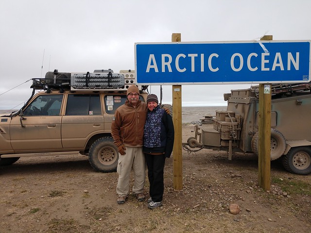
Driving through town there were many wooden buildings. We thought about how cold it must be in the winter. We headed to 'the point' where there was an informal campsite on the banks of Kugmallit Bay, the Beaufort Sea , on the Arctic Ocean.
The weather was cold, windy, and rainy. As we stood on the rocks by the water we could feel and taste the salty spray from the waves hitting the rocks. There were a couple of other people camping here and there was a single porta potty that was fouled. That combined with the weather, made our decision to drive back to Inuvik easy.
There was a local guy smoking white fish and we tried a sample, I think it is an acquired taste. We stopped at the grocery store out of curiosity. The shelves were well stocked; a gallon of milk only 12.99 CDN. We purchased our 'I made it to Tuk' stickers and headed south.
We arrived back to Inuvik and this time Happy Valley Campground had space for us. We headed to the showers and caught up on some laundry. Lisa and I took a walk to the grocery store and picked up some supplies, then to the Igloo church, which was closed.
Back at camp I got the pressure cooker going and soon we would be having chili for dinner. The pressure cooker really is a must have to make nourishing meals in a short time.
After dinner, we walked around the campground and saw people from all over. We met a young family traveling full-time (Lifestyle Overland) with their 4Runner and Turtleback trailer. They were headed to Tuk and then Deadhorse.
The next morning, we fueled up and chatted with the gas station attendant. He was impressed we drove all the way from Texas to visit his homeland. He proudly shared whale hunting videos and caribou, polar bear hunting pictures.
Fuel tanks filled, we headed out of town and stopped at the visitors' center. As with most Canadian visitors' centers, there was a wealth of information about the area, the native peoples....and nice restrooms. We also received our Canada's Northwest Territories Certificate of Arctic Circle Chapter Order of Adventurers.

To get your copy of the
Spring 2019 Issue:
Follow us on Facebook, Twitter, and Instagram to get up-to-date industry news, events, and of course, amazing adventures, stories, and photos!


